Here's the final result, colorized because I felt like it.

The main table generates Terrain features. Roll a d20 and a d12, three times. The default terrain is mostly forested with streams and rolling hills, if the terrain table doesn't change any of that.
| Terrain (d20, thrice) | ||
| 1 | A high Mountain range down the middle of this country or along one side. Crossing requires mountaineering or knowledge of hidden passes. | The range/cliff runs (d12) 1-4: north/south, 5-7: east/west, 8: north-west/south-east, 9-12: north-east/south-west. |
| 2-3 | A cliff, Escarpment, or range of mountains divides this land from a higher or lower one. Many waterfalls where streams cascade down. | |
| 4-5 | One may walk with ease along the tops of mostly-parallel Ridges. | |
| 6 | One great River flows down from mountains/hills towards the sea, gaining water from several streams as it goes. | Water flows down to the coast or (d12) 1: north, 2-3: north-east, 4-5: east, 6-7: south-east, 8-9: south, 10-11: south-west, 12: west. |
| 7-8 | Waterways cut deep Ravines, nearly impossible to walk in. | |
| 9 | Many parallel Creeks merge together flowing out of this land. | |
| 10 | Mostly Flat. Braided river or meandering river with oxbow lakes. | |
| 11-13 | Denser or harder to travel through than most countries: | (d12) 1-3: rainy Jungle of towering trees and incredibly thick undergrowth (a good country for Goblins), 4-6: Swamp: mosquitoes, deep mud, and rotting trees, 7-9: Floodplain: grassland turns to shallows, 10-12: dense thickets and Tall-Grass instead of woodland, too tall to see over, easy to be ambushed. |
| 14-15 | Part or all of this country is Treeless: | (d12) 1-2: Highlands above the tree line, 3-6: windswept grassy Plains, 7: rocky Scrubland of meager plants, 8-9: Bog/Muskeg or frozen Tundra, 10-11: bare Rock once scoured by glaciers, 12: sandy Desert. |
| 16 | Waves beat against rocky Cliffs, difficult to find a safe landing. Streams end in waterfalls at the coast. Mountains are likely. | The sea lies to the (d12) 1: north-east, 2-4: east, 5-7: south-east, 8-10: south, 11: south-west, 12: This country is an island or a chain of isles, or it has many isles offshore. (If far from the sea, this is the shore of a great lake instead.) |
| 17 | Thin Barrier Islands of sand dunes run along the coast, enclosing an inner sound/bay. Mainland side of the sound has shallow mudflats and marshes, difficult to say where the water begins and the land ends. | |
| 18 | Deeply Indented coastline, bay, many inlets, streams, coves, and isles. | |
| 19 | Long sandy spit or grassy Cape, straight coast with a few harbors or inlets. Dangerous sand/gravel bars in river mouths. | |
| 20 | A natural Wonder dominates this country. (Details on a different table.) | |
| random Wilderness Country | |
| terrain | |
| terrain | |
| terrain | |
(That took longer to type up than I expected. Later on I'll upload the tables for inhabitants and other details.)
Green Hills
Time to start rolling. Here's what I get for the first country:
- Long sandy spit, grassy cape, straight coast. Sea to the northeast.
- Waterways cut deep ravines. Water flows down to the northeast.
- Also ravines, but to the south.

From the other tables:
- Rope bridge still maintained every year.
- Elven resource-gathering settlement (Round Beach), trading post (Silver Post), fort (Fort Wilderness).
- Goblins: two dwellings (Winter Home and Lodgepole) compete for hunting grounds.
- Country named for a prominent geographical feature.

Candlewood Country
I'm curious to know where those streams flow to the south, so let's roll up the Terrain of another country and hope it fits there:
- Rainy jungle of towering trees, thick undergrowth.
- Swamp, mosquitoes, mud, rotting trees.
- Ravines, water flows to the west.

From the other tables, it turns out this is a busy area:
- Obstacle on the border: river blocked by waterfall (there are other options, but I like this one).
- Flooded lowlands. (I'll try to turn some of the swamp waterways into a lake.)
- Well established trail.
- Giants: two rival houses, contested border. Their names are Circle Dead Knife and Castle of Broken Smoke.
- Goblins: populous region with good hunting and no outsiders save the occasional giantish trader.
- Humans: trade center, other towns. The main town is called Flint Crossing. For one of the towns I rolled up the name Poverty Ford. I was hoping for something happier so I rerolled it and got Misery.

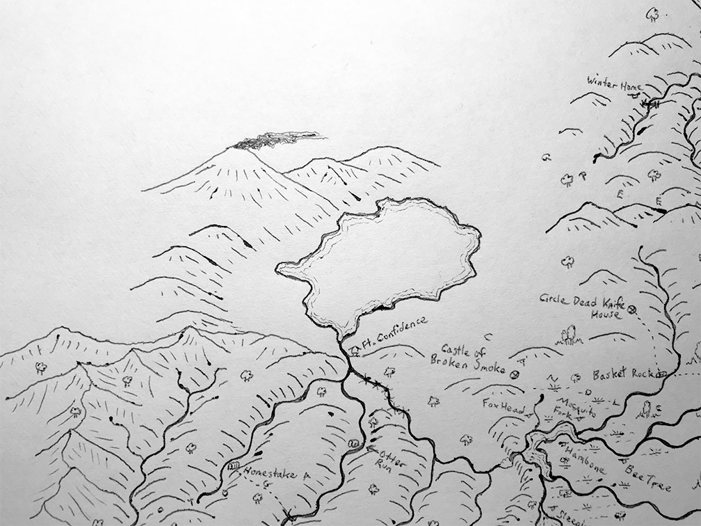
Otoga Country
Let's see what lies below the falls. Rolling on the Terrain table for a new country:
- Waves beat against rocky cliffs, difficult to find a safe landing. Streams end in waterfalls at the coast. Mountains are likely. The sea lies to the southwest. (If far from the sea, this is the shore of a great lake instead.)
- One may walk with ease along the tops of mostly-parallel ridges that run northeast/southwest.
- Many parallel creeks merge together flowing out of this land, down to the north.

From the other tables, this country has:
- Two obstacles on the border. I'll go with high mountains to the northwest and miles of log-jam on the river flowing down from the Candlewood country.
- Elven fort (Fort Confidence). Outside the fort there are no elves in this country, but their guns and other trade goods are widespread.
- Human tribe struggling over resources. I'll mark a few of their towns: Otter Run, Homestake, Greatwater.
- Rope bridge maintained every year.

Lake Nontomaqua
I'd still like to find out how to get back to the sea from here, so let's follow the river as it flows north into another country:
- Natural wonder: the snow-capped Volcano looms above this country, surrounded by a lush and verdant landscape with plants that grow nowhere else.
- Cliff, escarpment, mountain range dividing this country from a higher one. The cliff/range runs northwest/southeast.
- Waves beat against rocky cliffs with waterfalls, mountains likely, the sea to the east. (As before, if this is far inland, it's a great lake instead of the sea.)
This is getting close enough to the Green Hills that the two countries need to be joined together a bit. Maybe some streams flowing west out of the hills into the lake would be good. Other details for this country:
- Elven guns and trade goods, but no elves.
- Human trade center, many other towns. The central town is called Medicine Tree, so I think it should be at the foot of the volcano where rare plants grow. Other towns: Storm Haven, Old Fish Landing, Rough and Ready.
- Giants: two rival houses: Dead Crow Station, Diamond Bear House.

White Mountains
We still haven't made it down to the sea, yet, so let's keep rolling:
- Long sandy spit, grassy cape, straight coast with a few harbors/inlets. Sea/lake to the southeast.
- Natural wonder: deep canyon dividing the land, several days' travel to the bottom where you find the remains or even survivors of a famous lost expedition.
- High mountain range running northwest/southeast.
- Giantish house (Double Walking Bear) weaker than in olden days.
- Two goblin dwellings (Dead Hawk, Lookout) compete for hunting grounds.
- Human tribe struggling over resources. Their principal town is Pine Brook.
- Invasive vines overwhelm the land.
- Steps cut in rock.

Mekaya Country
Let's wrap this map up. I'd still like to know what's along the sea-coast north of the river outlet. I'm also curious what's upriver from the canyon through the White Mountains, but that can wait for another time.
Along the sea is the Mekaya Country:
- Thin barrier islands, sea to the southeast.
- Many parallel creeks merge together flowing down to the east.
- Mostly flat, braided river flowing down to the east.
- Infested swamps. Locusts/mice/birds that devour food.
- Humans: tribe struggling for resources, newly-arrived tribe causing strife, tribe from neighboring country extends here. Towns: Owl Rock, Relief, Shadow Camp.
And that's the whole map:

This is plenty of room for adventuring in. (I've been ignoring results from the other tables that don't affect the map itself, but those have suggested lots of adventure as well.)
Thanks for following along!
These are so much fun to read! Keep it up.
ReplyDeleteWhen are you planning on uploading a natural wonders table for rolling a 20? Or is there one that already exists that you'd recommend?
ReplyDeleteI've got one ready that I really should get around to uploading.
DeleteCan't wait until you release the other tables you mentioned here (honestly, seeing the generators you allude to in this post and the Copper Isle one truly does excite me. If you ever release that book, I'm definitely getting a copy).
ReplyDelete